Traffic & Travel Information Services
This introductory gives an overview of the structure of Traffic & Travel Information Services and describes from different points of view aspects, which are common to all services from the whole spectrum of Traffic & Travel Information Services-services.
In general the intention Traffic & Travel Information Services- Services is to provide the European traveller with comprehensive real time traffic information allowing for well-informed travel decisions before setting off (pre-trip information) as well as information during the journey (on-trip). It includes real time information concerning the TEN-T road network as well as interfaces with peri-urban networks and with other transports modes, especially in urban areas.
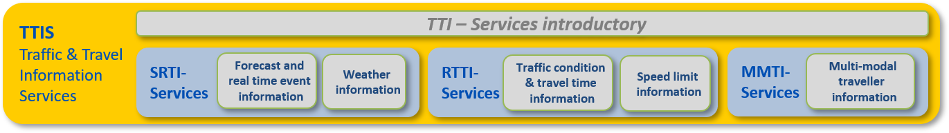
Figure 9 outlines the relationship between the Traffic and Travel Inforamtion introductory and individual Guideline parts. The Traffic & Travel Information Services introductory should be read with each Guideline TIS-DG02 to TIS-DG07.
This content-based approach to the production of the Guidelines for traveller information requires a strong understanding of the actors and processes which govern the relationships in this field. An appreciation of the current actors in the value chain is also an important prerequisite to the development of any business models for traveller information as outlined in the corresponding section of this report.
With regard to the Information „Traffic & Travel Information Service” means the collection and provision of:
- Safety-Related Traffic information, which is information about expected or unexpected Events and exceptional Weather Conditions
- Real-Time Traffic information, which is information about Traffic conditions (Level of Service), Travel times, Speed Limits and
- Multimodal Travel Information
on identified road segments of the network. As part of a global information strategy, Traffic & Travel Information can be provided both on-trip and pre-trip using different information channels.
Safety-Related Traffic Information Services
Forecast and Realtime Event Information
“Forecast and Real Time Event Information Services” means the provision of information about both expected and unexpected events to road users on identified road segments of the network and interfaces.
„Events“ are defined as – expected or unexpected – abnormal situations, which may lead to adverse effects on the road as regards to traffic safety, efficiency and the environment. There are two categories of events:
- expected events, e.g.:
- Road works, traffic jams, closures, parking rest info, strikes, protest rallies, major events (sports games, concerts, festivals…), and frequent overloading (commuter and holiday travel), parking rest area information, road/bridge/tunnel/lane/border closures…
- unexpected events, e.g.:
- incidents, accidents, road/bridge/tunnel/lane closures, objects on the road (objects, animals, people), ghost-drivers, parking and rest area information, sudden end of slow or stationary traffic, reduced vision, slippery surface (aquaplaning, ice, oil…), , long delays at borders…
Wheater Information Services
„Exceptional Weather Condition Information“ should be provided to users to notify them if awkward weather- or road conditions are expected on the road ahead or any part of a route. Depending on type of vehicle (public transport, car, HGV, motorbike) and goods carried. The provision of dynamic information about weather covers both weather information and weather warnings.
While weather information data covers e.g. conditions of road surface, visibility conditions and also infrastructure specific information on parts of the network such as bridges; which can be closed due to high wind conditions is dealt within the weather domain.
COMMISSION DELEGATED REGULATION (EU) No 886/2013:
The Delegated Regulation No 886/2013 classifies „Safety-Related Traffic Information“ as follows:
- (a) temporary slippery road
- (b) animal, people, obstacles, debris on the road
- (c) unprotected accident area
- (d) short-term road works
- (e) reduced visibility
- (f) wrong-way driver
- (g) unmanaged blockage of a road
- (h) exceptional weather conditions.
Real-Time Traffic Information Services
Traffic Condition and Travel Time Information Services
“Traffic Condition and Travel Time Information Service” means the provision of information on the traffic conditions (Level of Service) and travel times on identified road segments of the network.
„Traffic Condition / Level of service (LoS)“ is a qualitative measure used to relate the quality of traffic service. LoS is used to analyse road networks by categorising traffic flow and assigning quality levels of traffic based on performance measure shuck as speed, volume, delay etc. This is typically based on the continuity of flow.
„Travel time“ is the total elapsed time necessary for a vehicle to travel from one point to another over a specified route under existing traffic conditions.
Speed limit Information Services
„Speed limit information“ services are implemented to help ensure that the driver always and everywhere knows what the speed limit in force is. Speed limits can be static or dynamic; both can be included in information services, and can be provided to drivers via road signing, road markings and in-vehicle systems.
Under national legislative frameworks, road and traffic authorities have to erect and maintain prescribed speed limit signs on their roads. Data about speed limit signs is generally maintained as part of an asset register and can contribute a static speed limit database.
Dynamic speed limits take into account the real time traffic, road and weather conditions, better reflecting a safe speed. These are controlled via traffic control systems.
COMMISSION DELEGATED REGULATION (EU) 2015/962
The Delegated Regulation No 2105/962 classifies „Real-Time Traffic Information“ as follows:
- (a) road closures
- (b) lane closures
- (c) bridge closures
- (d) overtaking bans on heavy goods vehicles
- (e) roadworks
- (f) accidents and incidents
- (g) dynamic speed limits
- (h) direction of travel on reversible lanes
- (i) poor road conditions
- (j) temporary traffic management measures
- (k) variable road user charges and available payment methods
- (l) availability of parking places
- (m) availability of delivery areas
- (n) cost of parking
- (o) availability of charging points for electric vehicles
- (p) weather conditions affecting road surface and visibility
Those short-term data need not to be included in digital map updates as they shall not be considered as changes of a permanent nature.
The types of the traffic data include in particular:
- (a) traffic volume
- (b) speed
- (c) location and length of traffic queues
- (d) travel times
- (e) waiting time at border crossings to non-EU Member States.
Multimodal Travel Information
„Multimodal traveller Information“ is in parallel comparative information of different modes/means of transport and/or the combination of different modes/means of transport within the same route. The services offer information for at least public transport, car transport and usually pedestrian and bicycle transport.
Multimodal travel information services require data from the different transport modes road, rail, water- and airborne transport, walking, cycling and additional services such as parking.
COMMISSION DELEGATED REGULATION (EU) 2017/1926
The Delegated Regulation No 2105/962 classifies „Types of multimodal dynamic travel and traffic data“ as follows:
- Level of service 1
- Passing times, trip plans and auxiliary information:
- (i) Disruptions (all modes)
- (ii) Real-time status information — delays, cancellations, guaranteed connections monitoring (all modes)
- (iii) Status of access node features (including dynamic platform information, operational lifts/escalators, closed entrances and exit locations — all scheduled modes)
- Passing times, trip plans and auxiliary information:
- Level of service 2
- (a) Passing times, trip plans and auxiliary information (all modes):
- (i) Estimated departure and arrival times of services
- (ii) Current road link travel times
- (iii) Cycling network closures/diversions
- (b) Information service:
- Availability of publicly accessible charging stations for electric vehicles and refuelling points for CNG/LNG, hydrogen, petrol and diesel powered vehicles
- (c) Availability check:
- (i) Car-sharing availability, bike sharing availability
- (ii) Car parking spaces available (on and off-street), parking tariffs, road toll tariffs
- (a) Passing times, trip plans and auxiliary information (all modes):
- Level of service 3
- Trip plans:
- Future predicted road link travel times