ITS-Service Strategy
General Service Description
“Forecast and Real Time Event Information Services” means the provision of information about both expected and unexpected events to road users on identified road segments of the TEN-T network and interfaces.
“Events” are defined as – expected or unexpected – abnormal situations, which may lead to adverse effects on the road as regards to traffic safety, efficiency and the environment.
There are two categories of events:
- expected events, e.g.:
- Road works, traffic jams, closures, parking rest info, strikes, protest rallies, major events (sports games, concerts, festivals…), and frequent overloading (commuter and holiday travel), parking rest area information, road/bridge/tunnel/lane/border closures…
- unexpected events, e.g.:
- incidents, accidents, road/bridge/tunnel/lane closures, objects on the road (objects, animals, people), ghost-drivers, parking and rest area information, sudden end of slow or stationary traffic, reduced vision, slippery surface (aquaplaning, ice, oil…), sudden severe adverse weather, long delays at borders…
As part of a global information strategy, forecast and real-time event information services shall provide:
- Pre-trip warnings to drivers about upcoming expected events and known unexpected events
- On-trip warnings to drivers about expected and unexpected events
What is the Vision?
The main objective of providing forecast and real time event information and warnings to the road user is improving the safety and the efficiency of the network.
Expected and unexpected events can develop into a traffic bottleneck, due to abrupt reactions of uninformed drivers. However, if those drivers know the upcoming traffic situation in advance they would be prepared and could pro-actively adapt their speed and following distance, thus preserving smooth, stable and safe traffic flow.
Forecast and real time event information services allow traffic information to be factored into both pre- and on-trip journey planning. This can alter the departure times, assist the driver to take more effective routing decisions, select another means of transport or even alter the decision to travel.
The provision of information to drivers enhances the travelling experience even if the information does not directly impact on network efficiency or safety. Better-informed drivers tend to be calmer and hence more concentrated. Other impacts are the increased mode share of public transport and reduced air pollution.
Note: Forecasts can – and even should – provoke changes in the behaviour and actions of the different parties involved. If they do so, the resulting real traffic situation may lead to a different outcome than was originally predicted. This could lead to the impression that the original forecast was inaccurate.
What is the Mission?
The main service mission is to inform about expected or unexpected events in order to support the road user finding the best way to travel and to do so in a calmer and safer way.
This predictive or real-time information could be provided on-trip and pre-trip using different information channels, accessible or receivable by the road user via different end-user devices. The service may comprise common information as well as individual (personalised, on-demand) information.
Problems to consider:
- different organisational and technical conditions among traffic managers, road operators for the dissemination of information
take into account the individual backgrounds and requirements of each partner
promote dialogue between traffic operators along corridors for homogenous way of dissemination of information
- diverging interpretation of the infrastructure by the road users
communication to the road user as far as possible through clear and mono-interpretable pictorial signs. Use of language only as explanation for the signs used
- diversity of information portable with different presentation including on board system
promote use of common criteria for presenting information (i.e.: common color for level of service)
Distinctiveness to other ITS-services
Relevant information for this service is current changes in and forecast of events affecting the road users on its journey. Relevant complementary information, which is not part of the content of this Deployment Guideline and will be covered by other DGs, is:
- cause and duration of traffic disturbances, e.g. incidents, accidents (see TMS-DG05-08 Incident warning and management services), weather (see TIS-DG06 – Weather information services)
- consequences of traffic conditions, e.g. speed limits (see TIS-DG04 – Speed limits services) or traffic conditions and delays (see TIS-DG03/05 – Traffic condition and travel time services)
- recommendation of alternatives (e.g. re-routing or modal shift, see TMS-DG07 – Traffic management plan services for corridor and networks)
Contribution to overarching European ITS objectives
ITS-Service radar
The graph below provides a quantification of the added value of “Forecast and Real-time Event Information” services regarding the three main objectives of EasyWay which are: safety, efficiency and environment. The applied scales for the service radars are based on an expert view and not on specific scientific analysis.
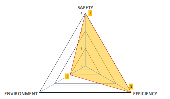
Safety
Information on events can help prevent accidents by warning drivers of dangerous situations, especially for unexpected events related to dangerous situations (flooding, ice …).
Environmental impact
It is commonly accepted that this type of information may lead to more efficient network use and in particular support greater use of public transport and by doing so reduce emissions
Network efficiency
More informed travel decisions (route choice, mode choice, time of travel) are expected as a result of the provision of event information.