Preliminary Remark
„The Deployment Guidelines are subordinated to the Delegated Regulations. The Deployment Guidelines pursue the goal of applying the legally binding Delegated Regulations to the specific ITS services. Table 7 shows the Deployment Guidelines affected by the Delegated Regulations.“
ITS-Core Services affected by European Delegated Regulations:
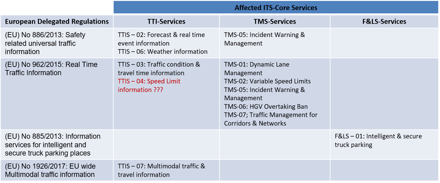
European Delegated Regulations (EU) No 886/2013 & (EU) No 962/2015 versus TTI & TMS – Core Services in terms of data/information:
Background
In 2013 the European Commission adopted the first two Delegated Regulations on the provision of Information by ITS-Services:
The Delegated Regulation No 885/2013 classifies „Information for safe and secure parking places for trucks“ as follows:
-
- 1. Static data related to the parking areas, including (where applicable)
- Identification information of parking area (name and address of the truck parking area (limited to 200 characters))
- Location information of the entry point in the parking area (latitude/longitude) (20 + 20 characters)
- Primary road identifier1/direction (20 characters/20 characters), and Primary road identifier2/direction (20 characters/20 characters) if same parking accessible from two different roads
- If needed, the indication of the Exit to be taken (limited to 100 characters)/Distance from primary road (integer 3) km or miles
- Total number of free parking places for trucks (integer 3)
- Price and currency of parking places (300 characters)
- 2. Information on safety and equipment of the parking area
- Description of security, safety and service equipment of the parking including national classification if one is applied (500 characters)
- Number of parking places for refrigerated goods vehicles (numerical 4 digits)
- Information on specific equipment or services for specific goods vehicles and other (300 characters)
- 1. Static data related to the parking areas, including (where applicable)
Contact information of the parking operator:
-
-
- Name and surname (up to 100 characters)
- Telephone number (up to 20 characters)
- E-mail address (up to 50 characters)
- Consent of the operator to make his contact information public (Yes/No)
- 3. Dynamic data on availability of parking places including whether a parking is: full, closed or number of free places which are available.
-
- The provision, where possible, of road safety-related minimum universal traffic information free of charge to users ((EU) 2013/886)
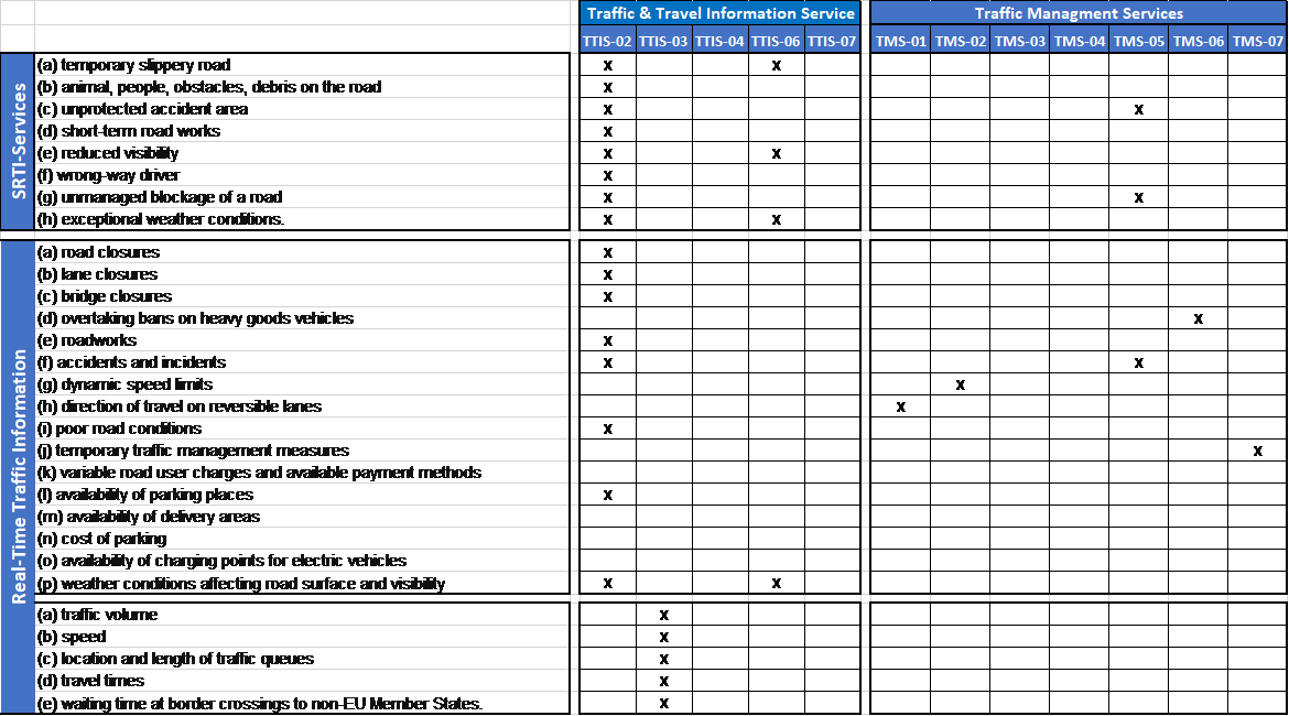
The Delegated Regulation No 886/2013 classifies „Safety-Related Traffic Information“ as follows:
-
- (a) temporary slippery road
- (b) animal, people, obstacles, debris on the road
- (c) unprotected accident area
- (d) short-term road works
- (e) reduced visibility
- (f) wrong-way driver
- (g) unmanaged blockage of a road
- (h) exceptional weather conditions.
Two additional Delegated Regulations were adopted in 2015 and 2017 respectively:
The Delegated Regulation No 2105/962 classifies „Real-Time Traffic Information“ as follows:
-
- (a) road closures
- (b) lane closures
- (c) bridge closures
- (d) overtaking bans on heavy goods vehicles
- (e) roadworks
- (f) accidents and incidents
- (g) dynamic speed limits
- (h) direction of travel on reversible lanes
- (i) poor road conditions
- (j) temporary traffic management measures
- (k) variable road user charges and available payment methods
- (l) availability of parking places
- (m) availability of delivery areas
- (n) cost of parking
- (o) availability of charging points for electric vehicles
- (p) weather conditions affecting road surface and visibility
Those short-term data need not to be included in digital map updates as they shall not be considered as changes of a permanent nature.
The types of the traffic data include in particular:
-
- (a) traffic volume
- (b) speed
- (c) location and length of traffic queues
- (d) travel times
- (e) waiting time at border crossings to non-EU Member States.
The Delegated Regulation No 2105/962 classifies „Types of multimodal dynamic travel and traffic data“ as follows:
-
- Level of service 1
- Passing times, trip plans and auxiliary information:
- (i) Disruptions (all modes)
- (ii) Real-time status information — delays, cancellations, guaranteed connections monitoring (all modes)
- (iii) Status of access node features (including dynamic platform information, operational lifts/escalators, closed entrances and exit locations — all scheduled modes)
- Passing times, trip plans and auxiliary information:
- Level of service 2
- (a) Passing times, trip plans and auxiliary information (all modes):
- (i) Estimated departure and arrival times of services
- (ii) Current road link travel times
- (iii) Cycling network closures/diversions
- (b) Information service:
- Availability of publicly accessible charging stations for electric vehicles and refuelling points for CNG/LNG, hydrogen, petrol and diesel powered vehicles
- (c) Availability check:
- (i) Car-sharing availability, bike sharing availability
- (ii) Car parking spaces available (on and off-street), parking tariffs, road toll tariffs
- (a) Passing times, trip plans and auxiliary information (all modes):
- Level of service 3
- Trip plans:
- Future predicted road link travel times
- Level of service 1